
Long ago, when the Earth had only one continent and one ocean, an earthquake rippled through western North America's great sand sea. The early Jurassic earthquake left its mark in the vast dunes that now form the famous red cliffs of Zion National Park in Utah, a new study finds.
The seismic waves violently shook the water-saturated ground beneath the giant dune field, sending liquefied sand spurting up through the dunes like a volcano, researchers believe. Some 180 million years later, these sand blowouts, which look like cylindrical pipes, were discovered in the Navajo Sandstone.
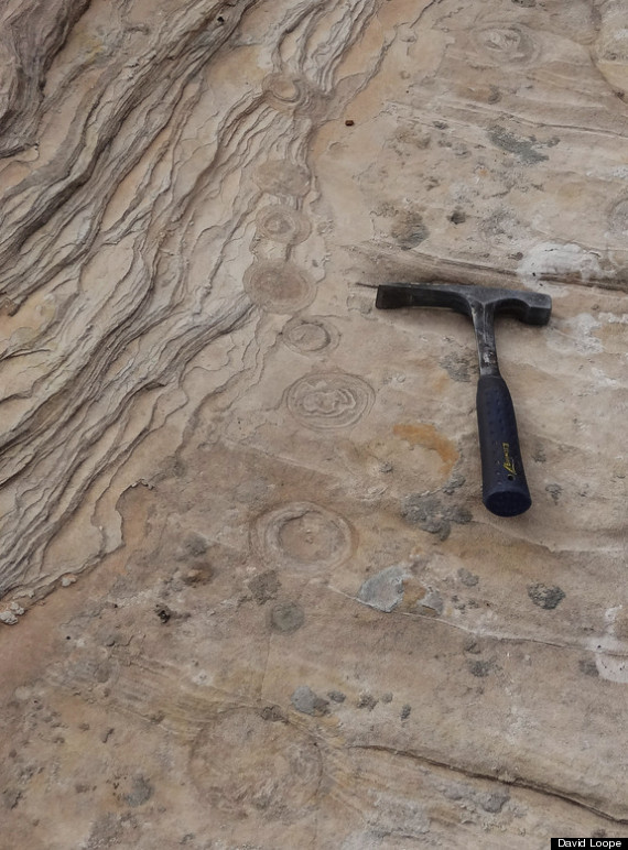 Sand pipes in the Navajo Sandstone are evidence of earthquakes during the Jurassic period, scientists say.
The sandstone is so finely bedded that the researchers can identify cyclic patterns, such as summer and winter layers. At one spot in Zion National Park, lead study author David Loope and his colleagues picked out a yearlong sequence of sand pipes, also called sand blowouts, that likely marks the main earthquake and seven aftershocks. [Images: Magnificent Geological Formations of the American West]
"The exposure is so complete you can see every detail," said Loope, a sedimentologist at the University of Nebraska in Lincoln. "As you walk over these outcrops, if they're messed up in any way, you think, 'That's interesting.' It might be the burrow of an animal, the tracks of a dinosaur or soft sediment deformation."
Before flat-lying layers of sediment become rock, forces such as earthquake waves, landslides or powerful storms may stir up fantastical whirls and folds. The Navajo Sandstone is known for its zigzagging beds, but the occasional swirling, swooping layers come from soft sediment deformation, geologists say. In places like Navajo Canyon and the Glen Canyon Dam in Arizona, some of the disturbed layers have been attributed to Jurassic earthquakes.
No sandworms here
The Navajo Sandstone is part of a family of nearly pure quartz sandstones that stretches from Wyoming to California. The great Jurassic dune field covered an area of around 241,000 square miles (625,000 square kilometers) for about 15 million years, from between 192 million and 178 million years ago, researchers believe.
Though the dunes are often compared to the arid Sahara desert, monsoonal rains and winds dominated their climate, studies show. Lenses of mud and limestone from playas (temporary lakes) and oases are common in the Navajo Sandstone, and helped preserve Early Jurassic dinosaur, plant and insect fossils and tracks in their mud deposits. The seasonal rains may have left enough liquid to hide a layer of water-saturated sand near the surface, beneath the dunes.
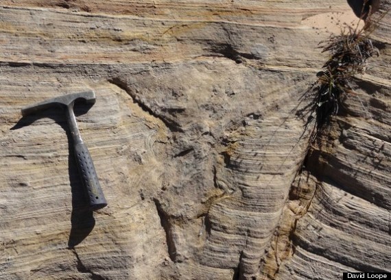 A close-up view of a sand blowout in the Navajo Sandstone in Zion National Park.
The Four Corners region of Utah lay close to latitude 10 degrees north when the sand sea marched across the west. At the time, North America was part of a supercontinent called Pangaea, which was just starting to crack up. Loope thinks the supercontinent created strong northwesterly winter winds, which pushed the dunes southeast by about 3 feet (1 meter) every year during the Northern Hemisphere's winter. [In Images: How North America Grew as a Continent]
The constant sand avalanches blown down by the advancing dunes created the perfect conditions for burying and preserving the sand pipes, Loope said. "Everything has to be just right, and it was just right in the Jurassic in this particular part of Utah. You don't see layering this nicely preserved in modern dunes," he told LiveScience's OurAmazingPlanet.
Loope mapped two sites in Zion Park with sand blowouts up to 13 feet (4 m) tall and 0.75 to 2 inches (2 to 6 centimeters) wide.
Finding the fault
The source of the earthquakes remains a mystery. In the Jurassic, western North America was bashed by fragmented volcanic arcs and microcontinents, sucked toward the continent by its subduction zone — or where two of Earth's plates collide and one dives below another, sticking and slipping in great earthquakes. The subduction zone could have triggered a massive earthquake up to magnitude 9, Loope said. But the subduction zone was about 300 miles (500 km) to the west of today's Zion National Park, noted Bob Biek, a geologist at the Utah Geological Survey, who was not involved in the study.
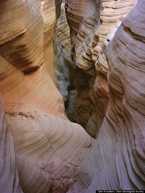 The Navajo Sandstone in the Grand Staircase–Escalante National Monument, Kane County, Utah.
"There was mountain-building going on in Navajo Sandstone time, but not where the Navajo itself was being deposited," Biek said.
Liquefaction features like sand blowouts usually have a local culprit. For example, the February 2011 Christchurch earthquake and its aftershocks created a sequence of sand pipes remarkably similar to the Navajo Sandstone set, Loope said. The magnitude-6.3 quake was on a strike-slip fault, though Christchurch is near a subduction zone. Loope and his colleagues estimate that a magnitude-5.0 earthquake would provide enough force to punch wet sand through the Navajo Sandstone's overlying dunes. [Video: New Zealand Quake Shook Ground Like Jelly]
"I would say it had to have been pretty close," Loope said.
Email Becky Oskin or follow her @beckyoskin. Follow us @OAPlanet, Facebook & Google+. Original article on LiveScience's OurAmazingPlanet.
Related
Before You Go
