
The Suomi NPP satellite captured views of the blackouts caused by superstorm Sandy at around 2 a.m. Nov. 1. NASA's Earth Observatory website has a comparison of before and after photos. The reference image was taken on Aug. 31. In these photos, illuminated swaths of uptown Manhattan, Brooklyn and Philadelphia stand in stark contrast to the darkened areas of the Jersey Shore, lower Manhattan, Coney Island, the Rockaways and outlying suburbs of New York City.
SCROLL FOR BEFORE AND AFTER PHOTOS
An estimated 8 million people lost power because of the storm, according to Our Amazing Planet.
Sandy became a tropical storm in the Caribbean on Oct. 22 and roared northward on a path of destruction. LiveScience has a detailed infographic outlining Sandy's lifespan. Earlier this week, NASA also a released a time lapse of Sandy from start to finish made of images taken from some of its observatories.
The Suomi National Polar-orbiting Partnership (NPP) is a joint project of NASA, NOAA and the Department of Defense. Images were taken with the observatory's Visible Infrared Imaging Radiometer Suite (VIIRS). An additional comparison of the affected areas in New York, New Jersey and Pennsylvania taken from Suomi NPP can be viewed at NASA's website.
BEFORE: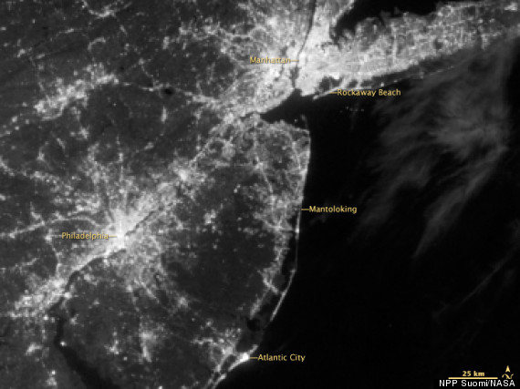
AFTER: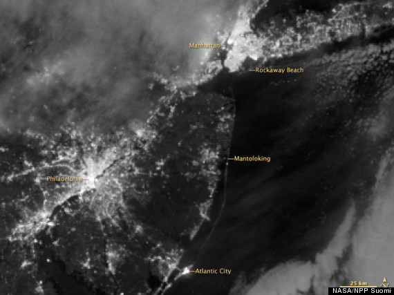
Live Updates: